Marinas, Boat Dealers, Fishing Charters, Waterfront Dining, Lodging, Diving,
Attractions, Boat Repair, Snorkeling, Kayaking, Sailing, Watersports & More!


Search For
  Near       All Categories

Home | Boating | Fishing | Diving | Water Sports | Boating Safety | Environment | Weather | Photo BlogAdd Your Company to the Directory


You Are Here > Home > Marine Weather > Coastal Waters Forecasts
Florida
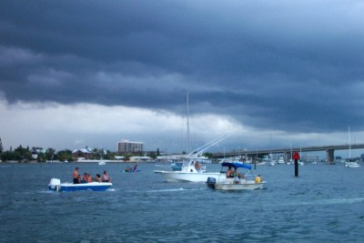
 Coastal Waters Forecasts

Coastal Waters from Fernandina Beach to St. Augustine

Coastal Waters from St Augustine to Flagler Beach

Coastal Waters from Flagler Beach to Volusia.Brevard County Line

Coastal Waters from Sebastian Inlet to Jupiter Inlet

Coast Waters from Jupiter Inlet to Deerfield Beach

Coastal Waters from Deerfield Beach to Ocean Reef

Biscayne Bay

Florida Keys

Coastal Waters from East Cape Sable to Chokoloskee

Gulf Waters from Chokoloskee to Bonita Beach

Gulf Waters from Bonita Beach to the mouth of the Suwanee River

Gulf Waters from Suwanee River to Tarpon Springs

Gulf Waters from Bonita Beach to Englewood

Coastal Waters from Suwannee River to Apalachicola

Coastal Waters from Apalachicola to Destin

If You Are Caught In A Thunderstorm

  • Make sure everyone aboard is wearing a life jacket.
  • Secure all loose gear, hatches or ports
  • Determine your location and the best course back to shelter.
  • Keep a sharp lookout for other boats and obstructions.

Once The Storm Hits

  • Try to take the first (and heaviest gusts of wind on the boat, not abeam. Heading into the wind is the most seaworthy position for most small boats.
  • Approach waves at a 45° angle to keep the propeller underwater, to reduce pounding, and to provide a safer and more comfortable ride.
  • If there is lightning, unplug radios and all electrical equipment.
  • Stay low. don't make yourself the tallest target.
  • Keep away from metal objects that aren't grounded to the boat's protection system.
Search the Business Directory (Browse All Categories)
Boat Covers, Tops & Upholstery Boat Lifts
Cleaning & Detailing Canvas
Charts & Maps Electronics
Insurance Life Boats & Rafts
Safety Equipment & Clothing Solar Equipment & Supply
Survival Equipment & Supplies TV, Radio & Internet


Beaufort Scale of Wind Force
Developed by Admiral Sir Frances Beaufort in 1805 to determine the effects of wind on water.

Force 0: Calm. Winds less than 1 mph.

Force 1: Light air. Winds 1-3 mph. Ripples on the water's surface.

Force 2: Light breeze, 4-7 mph. Small wavelets developing.

Force 3: Gentle breeze, 8-12 mph. Large wavelets with scattered whitecaps.

Force 4: Moderate breeze, 13-18 mph. Waves 2-3 feet with whitecaps becoming numerous.

Force 5: Fresh breeze, 19-24 mph. Waves 4-7 feet. Sea spray begins.

Force 6: Strong breeze, 25-31 mph. Waves 7-14 feet. White caps everywhere. Spray increasing.

Force 7: Near gale, 32-38 mph. Seas 14-18 feet. Foam begins to blow in streaks.

Force 8: Gale, 39-46 mph. Blinding foam begins blowing in streaks.

Force 9: Strong gale, 47-54 mph. 20 foot waves.

Force 10: Storm. Wind 55-63 mph. Waves 20-30 feet.

Force 11: Violent storm, 64-73 mph. Waves 30-45 feet.

Force 12: Hurricane, 74-82 mph. Air filled with foam. Waves as high as 50 feet.

Privacy Policy | Advanced Search | Photo Gallery | Add Your Company To The Directory | Contact Us | Advertise

© 2001-2014 Florida Marine Guide.com  All Rights Reserved. 
All logos and trademarks in this site are property of their respective owners.